S.Amdt. 4050
What it does: Rewrites page 10, lines 9–16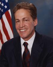 Sen. Norm Coleman (R-MN)
What it changes
1 change to S. 2611
Rewrites page 10, lines 9–16
ReplacesPrinted pageRemoves page 10, lines 9–16 of the printed bill. See that page
Inserted: (a) Acquisition.--Subject to the availability of appropriations, the Secretary shall--
Inserted: (1) procure additional unmanned aerial vehicles, cameras, poles, sensors, and other technologies necessary to achieve operational control of the international borders of the United States and to establish a security perimeter known as a "virtual fence" along such international borders to provide a barrier to illegal immigration; and
Inserted: (2) acquire and utilize real time, high-resolution, multi-spectral, precisely-rectified digital aerial imagery to detect physical changes and patterns in the landscape along the northern or southern international border of the United States to identify uncommon passage ways used by aliens to illegally enter the United States.
Original wording
On page 10, strike lines 9 through 16, and insert the following:
Read automatically from the Congressional Record. Check the original before relying on it.
As printed
SA 4050. Mr. COLEMAN submitted an amendment intended to be proposed by him to the bill S. 2611, to provide for comprehensive immigration reform and for other purposes; which was ordered to lie on the table; as follows:
On page 10, strike lines 9 through 16, and insert the following:
(a) Acquisition.--Subject to the availability of appropriations, the Secretary shall--
(1) procure additional unmanned aerial vehicles, cameras, poles, sensors, and other technologies necessary to achieve operational control of the international borders of the United States and to establish a security perimeter known as a “virtual fence” along such international borders to provide a barrier to illegal immigration; and
(2) acquire and utilize real time, high-resolution, multi-spectral, precisely-rectified digital aerial imagery to detect physical changes and patterns in the landscape along the northern or southern international border of the United States to identify uncommon passage ways used by aliens to illegally enter the United States.
Legislative Activity
Stay on top of the latest movement without scrolling through every action
Senate amendment submitted
May 17, 2006